Stephen H. Long Trail 1819 — 1820
Day 27: September 19th, 2008 La Junta (Vogel Canyon, Picketwire Canyon)


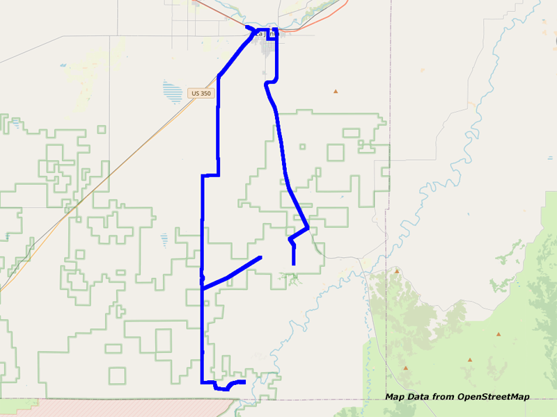
Map La Junta to Vogel Canyon and Picketwire Canyon
Thanks to my ear plugs, I was able to sleep pretty well. Just before seven I get up and make myself ready. Because there is no one currently at the reception, I start my search for the Village Inn, which they recommended to me yesterday. Therefore I take the Frontage Road and not the Highway. But I am not able to reach the Village Inn there. It is so far from the center that I have to take the Highway. To my surprise, there is even a Wal–Mart around!
But for now, I am looking for a breakfast. Around a quarter past nine I pay at the Village Inn and quickly drive over to the Wal–Mart I have seen before. There are again some CDs on sale, which I am interested in. It seems that I am slowly getting over my limit…
Around a quarter to ten I start my search for a gas station. But my GPS software takes me again pretty weird through the area, so that I am not passing any gas station. Therefore I drive back again and follow Highway 50. There I find a Phillips 66 where I stop to gas up.


Highway 109, CO


CR802/David Canyon Rd, CO
Then I take Highway 109 to Vogel Canyon. This hike was originally planned for yesterday. But I arrived yesterday simply too late to start this hike.


Vogel Canyon Trail, CO


Vogel Canyon Trail, CO


Vogel Canyon Trail, CO


Petroglyph, Vogel Canyon Trail, CO


Vogel Canyon Trail, CO


Vogel Canyon Trail, CO


Vogel Canyon Trail, CO


Vogel Canyon Trail, CO


FS505A, CO


FS505A, CO
There I meet Tom and Sheila. He once worked for Bayer in Cologne. They both give me some good advice for the Picketwire Canyon hike. At the end of this trail we say good–bye and I stay there to take some more pictures and video. Then I also start my hike back. When I arrive at the parking lot, I meet them both again and also his dad Sam. He is still living in this area. But Tom and Sheila are now living in Kansas City and they are just visiting here. Their dogs welcome me with snarling and barking, like on the trail. When saying good–bye, I hand them over one of my business cards. Sheila is really excited, because she wants to know how far I will make it into the Picketwire Canyon.


CR802/David Canyon Rd, CO


CR25/Rourke Rd, CO


CR25/Rourke Rd, CO
Around a quarter to twelve I leave to reach the Picketwire Canyon now.


CR B, CO
The road is really well posted with signs. Also the 4WD Trail to the second parking lot can be easily found. However, this road is way more easily driveable than what I expected. There are some small hills and washouts in the road. But if it is dry, you could almost drive it in a regular passenger car. Well, it shouldn’t be a lowered vehicle. But with my SUV I can easily drive it with comfortable 20mph.


Picketwire Canyon Trail, CO


Picketwire Canyon Trail, CO


Picketwire Canyon Trail, CO


Picketwire Canyon Trail, CO


Ruin, Picketwire Canyon Trail, CO


Stove, Picketwire Canyon Trail, CO


Picketwire Canyon Trail, CO


Picketwire Canyon Trail, CO


Picketwire Canyon Trail, CO


Picketwire Canyon Trail, CO


Picketwire Canyon Trail, CO


Picketwire Canyon Trail, CO


Purgatoire River, Picketwire Canyon Trail, CO


Purgatoire River, Picketwire Canyon Trail, CO


Ruin Dolores Mission, Picketwire Canyon Trail, CO


Ruin Dolores Mission, Picketwire Canyon Trail, CO


Cemetary Dolores Mission, Picketwire Canyon Trail, CO


Cemetary Dolores Mission, Picketwire Canyon Trail, CO


Purgatoire River, Picketwire Canyon Trail, CO
Finally I arrive at the trailhead. First it goes really steep down the hill. This stretch would be tough to drive. I would not try this with a stock SUV. But with my lifted truck, this should work out quite well. Even when there is just at the beginning a step in the rock. But I have been on real rough roads already.
But, unfortunately, you are only allowed to drive here in a guided group. And this only happens every Saturday. Therefore I hike into the canyon. I plan 4 hours for my hike, 2 hours in either direction. This takes me to the former graveyard of Dolores Mission and close to the Purgatoire River.


Picketwire Canyon Trail, CO


Purgatoire River, Picketwire Canyon Trail, CO


Picketwire Canyon Trail, CO


Picketwire Canyon Trail, CO


Butterfly, Picketwire Canyon Trail, CO


Picketwire Canyon Trail, CO


Picketwire Canyon Trail, CO


Picketwire Canyon Trail, CO
Around half past three I turn around and start my hike back. Also on my way back I have some very nice views of the surrounding canyon landscape. But the steep incline at the end is getting extremely strenuous, especially when you have now been hiking 8 miles around here and another around 3 miles in the Vogel Canyon.
Around half past five I am pretty exhausted back at my car. Especially my left shoulder hurts. I assume it is due to my camera bag, which was hanging there all the time…


CR B, CO


CR B, CO


CR25/Rourke Rd, CO
Slowly I drive back on the easy 4WD Trail.


Cattle, CR25/Rourke Rd, CO


CR25/Rourke Rd, CO


Tarantula, CR25/Rourke Rd, CO


Buzzard, CR25/Rourke Rd, CO


Buzzard, CR25/Rourke Rd, CO


Pronghorn, CR25/Rourke Rd, CO


Pronghorn, CR25/Rourke Rd, CO
Then I am driving faster on the good gravel roads. They are really good to drive on. However, there are a lot of tarantulas running over the roads. One time I stop just in time to get a picture of this animal. Somehow, these monsters are really frightening to look at. There are also some deer and pronghorn fleeing from my car on this gravel road. But thanks to my zoom in my photo I am able to get some nice shots of them. Also a buzzard is so nice, to sit down on a telegraph pole after fleeing for a short while. Now you are starting to wish to have a better zoom on the photo…
Now I continue on to Highway 350, passing countless spiders. Finally I reach the paved highway, which takes me back to La Junta. Back at the motel I put my stuff into the room. Then I check my emails. Because I am still good in times I check the video taping of today. That is not taking me too long this time. So I am able to walk over for dinner just past eight.
Today I try the Mexican restaurant next to my motel. They are not really busy. It seems that most of the guests are from the Holiday Inn Express next to it. The meal tastes really good. Only the tortillas could be one more. You cannot fill them up this much to squeeze everything in the two tortillas.
Around half past nine I pay and walk back to my motel. There I write my diary first and start to listen to my new CDs. Then I do my bookkeeping and take a look at my GPS coordinates before I go to bed around eleven…
- Sights
- Vogel Canyon (free)
- Withers/Picketwire Canyon (free)
- General
- Breakfast: Village Inn, La Junta
- Dinner: Felisa’s Mexican Food & Lounge, La Junta
- Motel: Super 8, La Junta
- Distance: 68 miles
