John Colter Trail 1807 — 1808


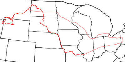
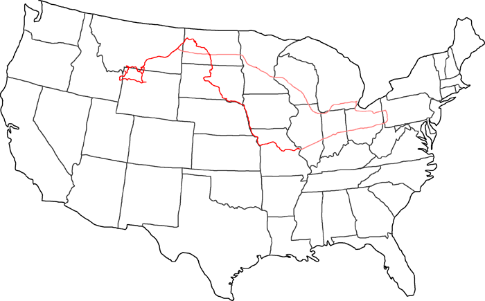
Map of John Colter Trail
In 2005 I follow the trails of John Colter and Manuel Lisa. Lisa was the first trader, who established a trading post at the Yellowstone River. In the meantime, John Colter was sent out by foot to meet the Indians in their winter quarters and to tell them, that there is a new trading post at the Yellowstone. On his trail, he saw the wonders of Yellowstone and was the first white man to tell about it.
First I follow the Interstates from Pittsburgh to St. Louis. Lisa followed the Missouri up to Omaha. There he met John Colter, a former member of the Lewis & Clark expedition. He was on his way to St. Louis to sell his winter catch of beaver fur. Lisa was able to win Colter for his plan to establish a new trading post.
When they reached the Yellowstone, they followed the river up to the mouth of the Big Horn River. There Lisa started the building of his trading post. Colter was sent out by foot with trading goods to meet the Indians, while the winter approached. Unfortunately there are no records of his trail. But most likely he followed the Yellowstone up to Pryor Creek in the area of nowadays Billings, Montana.
Then he followed Pryor Creek through Pryor Gap to the Pryor Mountains. There he saw for the first time the gigantic Sunlight Basin. He left Pryor Mountains to the southwest and reached Clark’s Fork. Passing Dead Indian Hill he reached nowadays Cody in Wyoming, which should later wear the name ‘Colter‘s Hell’.
He crossed the Absaroka Range and reached the Wind River Valley. From there he crossed the Wind River Range and reached nowadays Jackson Hole and the Snake River. The next mountain range he passed were the Teton Mountains. After crossing them, he turned north and followed the ridge up to the north end of Jackson Lake.
There he turned back east, crossed the Snake River and reached nowadays Yellowstone Park via Chicken Ridge. Probably he followed the ridge further and did not climb down to Yellowstone Lake. He reached the Yellowstone River above Yellowstone Lake, which he followed up to Canyon Junction.
He crossed Dunraven Pass and went on to Tower Junction, where he hit an old Indian trail through Yellowstone Park. Along Soda Butte Creek and Clark’s Fork he reached again Dead Indian Hill and Cody. He went via Lovell to the north and crossed again the Pryor Mountains at Pryor Gap. Eventually he followed the Yellowstone River back to the new established trading post, which he reached in spring after 6 months of traveling.
I follow from there the Interstates up to Detroit, where I visit my friends Jean & Matt. Then I drive on to Pittsburgh.
- Day 1: August 14th, 2005 Munich — Pittsburgh
- Day 2: August 15th, 2005 Pittsburgh (Mine)
- Day 3: August 16th, 2005 Pittsburgh (Chevrolet Dealer)
- Day 4: August 17th, 2005 Pittsburgh (Car Work)
- Day 5: August 18th, 2005 Pittsburgh (Car Work)
- Day 6: August 19th, 2005 Pittsburgh (Car Work)
- Day 7: August 20th, 2005 Pittsburgh — Cloverdale
- Day 8: August 21st, 2005 Cloverdale — St. Louis
- Day 9: August 22nd, 2005 St. Louis — Jefferson City
- Day 10: August 23rd, 2005 Jefferson City — Kansas City
- Day 11: August 24th, 2005 Kansas City — Omaha
- Day 12: August 25th, 2005 Omaha — Wagner
- Day 13: August 26th, 2005 Wagner — Pierre
- Day 14: August 27th, 2005 Pierre — Bismarck
- Day 15: August 28th, 2005 Bismarck — Dickinson
- Day 16: August 29th, 2005 Dickinson — Sidney
- Day 17: August 30th, 2005 Sidney — Miles City
- Day 18: August 31st, 2005 Miles City (A1 Quality Transmissions)
- Day 19: September 1st, 2005 Miles City — Red Lodge
- Day 20: September 2nd, 2005 Red Lodge — Cody
- Day 21: September 3rd, 2005 Cody — Worland
- Day 22: September 4th, 2005 Worland — Dubois
- Day 23: September 5th, 2005 Dubois — Jackson
- Day 24: September 6th, 2005 Jackson — Grant Village
- Day 25: September 7th, 2005 Grant Village (Heart Lake)
- Day 26: September 8th, 2005 Grant Village — Lake Village
- Day 27: September 9th, 2005 Lake Village — Canyon Village
- Day 28: September 10th, 2005 Canyon Village — Mammoth Hot Springs
- Day 29: September 11th, 2005 Mammoth Hot Springs — Old Faithful
- Day 30: September 12th, 2005 Old Faithful — Canyon Village
- Day 31: September 13th, 2005 Canyon Village — Cody
- Day 32: September 14th, 2005 Cody — Billings
- Day 33: September 15th, 2005 Billings (Pryor Mountains)
- Day 34: September 16th, 2005 Billings — Bismarck
- Day 35: September 17th, 2005 Bismarck — Minneapolis
- Day 36: September 18th, 2005 Minneapolis — Chicago
- Day 37: September 19th, 2005 Chicago — Detroit
- Day 38: September 20th, 2005 Detroit — Pittsburgh
- Day 39: September 21st, 2005 Pittsburgh (Preparation for Storage)
- Day 40: September 22nd, 2005 Pittsburgh (Mine)
- Day 41: September 23rd, 2005 Pittsburgh — Munich
