Lewis and Clark Trail 1803 — 1805


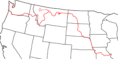
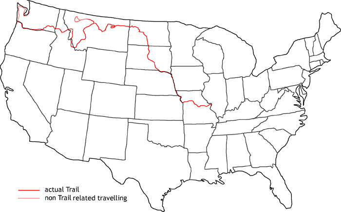
Map of Lewis and Clark Trail
The third and last part of my travel gets me from St. Louis along the whole Missouri to its sources, the Three Forks. From there I follow the Jefferson and Beaverhead River passed Dillon to the Lemhi Pass junction. Then I travel on to Salmon and Lost Trail Pass up to Missoula. The last pass over the Rockies is the Lolo Pass, which takes me from Highway 12 up to Lewistown/Clarkstown. Now I follow the Snake and Columbia River through Portland to the Pacific Coast. The finish of my travelling is to follow Highway 101 up north through the Olympic Forrest to Seattle.
In this last part of my journey I follow the legendary Lewis & Clark Trail in the years 1804 to 1806. In 1803 the Lousiana Purchase happened by president Thomas Jefferson. This purchase doubled the size of the formerly USA. But the people haven’t been very happy. This region was pretty much unknown. Only the Great Plains were known, which were also called the Great American Desert. The soil was not suitable for agriculture in the old times. It took a long time until the Americans understood the relevance of this genius buy by president Jefferson.
In 1803 president Jefferson gave the order to Meriwether Lewis to explore the new region and to find a waterway to the Pacific. This waterway would be very important for the cities at the west coast, because they were only able to get around the continent on the North or the South. The time loss and danger were very high. If the US would be able to find a waterway, they would be able to strengthen their economy.
In summer 1803 Meriwether Lewis left Pittsburgh and traveled up the Ohio to Louisville. There he picked up William Clark, who had from the beginning equal rights to Lewis. This equity was especially for this time very uncommon. Together they traveled up to St. Louis, where they spent the winter. On May 14th, 1804, they started the main travel. They traveled up the Missouri and held a couple of councils with the Indians. Another goal of the expedition was to gain the Indians as friends and companions. Therefore they had the “Jefferson Peace Medal” to demonstrate the peaceful intention of the expedition. The most important and most dangerous council happened with the Sioux Indians. This place would later be known as “Council Bluffs”.
End of October 1804 they reached the Mandan River close to nowadays Bismarck, ND. There they spent the whole winter. In April 1805 they traveled on. A couple of people have been sent back with documentation and results of the journey. The others followed on the Missouri. On this new leg, they had new companions by a french–canadian trader named Charbonneau and his Indian wife Sacagawea. This Indian woman, who gave birth to a sun in the winter, should be very important for the success of the expedition.
In June 1805 they reached the Great Falls of the Missouri. Lewis originally planned only a couple of days to get around the falls by land. But in the end they needed more than a month — valuable time, they would miss when crossing the Rockies. But for now they followed the Missouri to the Three Forks. This three rivers, which are the source of the Missouri, have been named Jefferson, Madison and Gallatin by them. They followed on the Jefferson, who got them to Sacagawea’s people, the Shoshones. They hoped to trade horses from them to cross the Rockies. But they lost another month until they were able to find them.
With the assistance of an Indian guide they crossed Lemhi Pass to Lost Trail Pass and followed on the Lolo Trail. There the winter surprised them, where they nearly starved. To make things worse their guide got lost and they had to climb back around 3000ft in height along steep und wooden hills to get back to the trail. But they made it and the Nez Perce Indians braught them to the Clearwater River. They built canoes and reached the Columbia River October 16th, 1805. On November 6th, 1805, Clark wrote the lines ‘Ocian in view! O! the joy’ into the diary.
In fact they only saw the big opening of the Columbia. It should take them another couple of days until they finally reached the Pacific. But they arrived in the middle of the autumn storms and it took another couple of weeks until they found their winter quarters. Close to nowadays Seaside in Oregon they built up Fort Clatsop, where they spent the winter until March 23rd, 1806.
Follow me now on my daily trails:
- Day 15: September 4th, 1999 St. Louis
- Day 16: September 5th, 1999 St. Louis — Jefferson City
- Day 17: September 6th, 1999 Jefferson City — Blue Springs
- Day 18: September 7th, 1999 Blue Springs — St. Joseph
- Day 19: September 8th, 1999 St. Joseph — Omaha
- Day 20: September 9th, 1999 Omaha — Sergeant Bluff
- Day 21: September 10th, 1999 Sergeant Bluff — Yankton
- Day 22: September 11th, 1999 Yankton — Wagner
- Day 23: September 12th, 1999 Wagner — Pierre
- Day 24: September 13th, 1999 Pierre — Mobridge
- Day 25: September 14th, 1999 Mobridge — Bismarck
- Day 26: September 15th, 1999 Bismarck — Garrison
- Day 27: September 16th, 1999 Garrison — Williston
- Day 28: September 17th, 1999 Williston — Glasgow
- Day 29: September 18th, 1999 Glasgow — Lewistown
- Day 30: September 19th, 1999 Lewistown — Shelby
- Day 31: September 20th, 1999 Shelby — Kalispell
- Day 32: September 21st, 1999 Kalispell — Great Falls
- Day 33: September 22nd, 1999 Great Falls — Helena
- Day 34: September 23rd, 1999 Helena — Dillon
- Day 35: September 24th, 1999 Dillon — Missoula
- Day 36: September 25th, 1999 Missoula — Clarkston
- Day 37: September 26th, 1999 Clarkston — Pasco
- Day 38: September 27th, 1999 Pasco — The Dalles
- Day 39: September 28th, 1999 The Dalles — Portland
- Day 40: September 29th, 1999 Portland — Seaside
- Day 41: September 30th, 1999 Seaside — Port Angeles
- Day 42: October 1st, 1999 Port Angeles — Seattle
- Day 43: October 2nd, 1999 Seattle — Munich
