Wilson Price Hunt Trail (‘Astorians’) 1811 — 1812


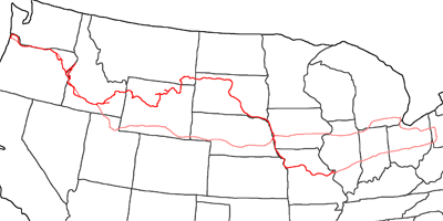
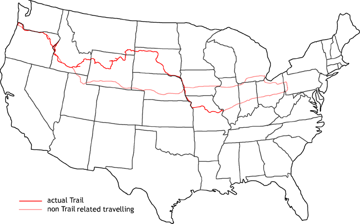
Map of Wilson Price Hunt Trail
In 2006 I follow the trail of Wilson Price Hunt, who will later be known as the leader of the ‘Astorians’. The employer was John Jacob Astor, who sailed a year before with his ship Tonquin around Kap Horn to establish Fort Astoria at the mouth of the Columbia River. Nowadays, the city of Astoria in Oregon can be found at this place. Hunts order was to find suitable places for trading posts and a more southern route over the Rockies, without entering the territory of the Blackfeet Indians.
First I follow the Interstates from Pittsburgh to St. Louis. The trail would follow now the Missouri up to Mobridge. But I have traveled this stretch of the Missouri often enough in my previous trails, so I decided to stay on the Interstates. When the river changes its course to the west, I will follow the trail on bigger highways until I reach Mobridge, where the main trail starts at the Arikara settlements.
I follow the Grand River west to Montana. Crossing Custer National Forest I head on further west. When Hunt reached the Powder River, he had to turn south, as the mountains were not passable. I reach Wyoming this way and by passing Gillette and Buffalo I arrive at the Bighorn Mountains.
At Shoshoni I arrive at the the Wind River, which I follow up to the north of Dubois. Hunt crossed the Wind River Range at Union Pass. But a fire stopped me there, and I had to turn back and cross the mountains at Togwotee Pass. Around nowadays Jackson Hole, Hunt tried to use canoes. But the Snake River was impassable. So the route goes via Teton Pass into Idaho. At Henry’s Fort Hunt sent out hunters to the north to refill their meat supplies. I follow Henry’s Fork up to Mesa Falls. Then I drive along the Snake River to Idaho Falls and Twin Falls. At Bruneau I take the opportunity to visit the sand dunes.
Hunt followed the Snake River further only for a short distance, before he was forced to leave the river and ride across the country up to nowadays Boise. Along Boise River he went to the Snake River and then up north. Due to the oncoming winter, the whole expedition nearly starved at Hells Canyon. Hunt met a group, he has sent out weeks before on a different route. They told him, that the canyon was impassable for horses. They turned back and followed the Snake River down to Weiser. From there, they turned west and reached Oregon. Following an old Indian Trail, they reached LaGrande and Pendleton. By following the Umatilla River, they reached the Columbia River, which showed them the way to Fort Astoria at the Pacific coast.
On bigger highways I drive back to Portland, where I reach the Interstates and follow them for the rest of my way back to Pittsburgh. In the area of Evanston, the first snow fall arrives, but with no bigger impact on my traveling. I make a small detour to Detroit to visit my friends Matt & Jean, before I finally reach Pittsburgh again.
- Day 1: August 13th, 2006 Munich — Pittsburgh
- Day 2: August 14th, 2006 Pittsburgh (Mine)
- Day 3: August 15th, 2006 Pittsburgh (Chevrolet Dealer)
- Day 4: August 16th, 2006 Pittsburgh (Chevrolet Dealer)
- Day 5: August 17th, 2006 Pittsburgh (Car Work)
- Day 6: August 18th, 2006 Pittsburgh (Car Work)
- Day 7: August 19th, 2006 Pittsburgh — Columbus
- Day 8: August 20th, 2006 Columbus — St. Charles
- Day 9: August 21st, 2006 St. Charles — Omaha
- Day 10: August 22nd, 2006 Omaha — Pierre
- Day 11: August 23rd, 2006 Pierre — Mobridge
- Day 12: August 24th, 2006 Mobridge — Lemmon
- Day 13: August 25th, 2006 Lemmon — Baker
- Day 14: August 26th, 2006 Baker — Gillette
- Day 15: August 27th, 2006 Gillette — Buffalo
- Day 16: August 28th, 2006 Buffalo — Worland
- Day 17: August 29th, 2006 Worland — Dubois
- Day 18: August 30th, 2006 Dubois — Jackson
- Day 19: August 31st, 2006 Jackson
- Day 20: September 1st, 2006 Jackson — Idaho Falls
- Day 21: September 2nd, 2006 Idaho Falls — Pocatello/Chubbuck
- Day 22: September 3rd, 2006 Pocatello/Chubbuck — Twin Falls
- Day 23: September 4th, 2006 Twin Falls — Mountain Home
- Day 24: September 5th, 2006 Mountain Home — Boise
- Day 25: September 6th, 2006 Boise (Mechanic)
- Day 26: September 7th, 2006 Boise — Ontario
- Day 27: September 8th, 2006 Ontario (Snake River)
- Day 28: September 9th, 2006 Ontario (Hells Canyon)
- Day 29: September 10th, 2006 Ontario — La Grande
- Day 30: September 11th, 2006 La Grande — Pendleton
- Day 31: September 12th, 2006 Pendleton — Troutdale
- Day 32: September 13th, 2006 Troutdale — Seaside
- Day 33: September 14th, 2006 Seaside — Meridian
- Day 34: September 15th, 2006 Meridian — Evanston
- Day 35: September 16th, 2006 Evanston — North Platte
- Day 36: September 17th, 2006 North Platte — Iowa City
- Day 37: September 18th, 2006 Iowa City — Detroit
- Day 38: September 19th, 2006 Detroit — Pittsburgh
- Day 39: September 20th, 2006 Pittsburgh (Chevrolet Dealer)
- Day 40: September 21st, 2006 Pittsburgh (Mine)
- Day 41: September 22nd, 2006 Pittsburgh — Munich
